The Face on Mars
July 25, 1976
PIA01141: Geologic 'Face on Mars' Formation
Target Name: Mars
Mission:Viking
Spacecraft: Viking Orbiter 1
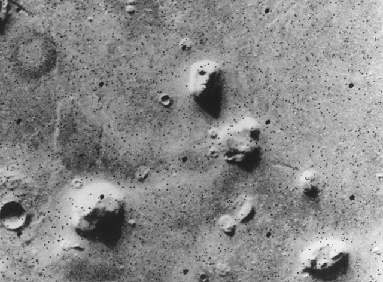
Original Caption Released with Image:
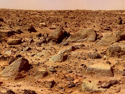
NASA's Viking 1 Orbiter spacecraft photographed this region in the northern latitudes of Mars on July 25, 1976 while searching for a landing site for the Viking 2 Lander. The speckled appearance of the image is due to missing data, called bit errors, caused by problems in transmission of the photographic data from Mars to Earth. Bit errors comprise part of one of the 'eyes' and 'nostrils' on the eroded rock that resembles a human face near the center of the image. Shadows in the rock formation give the illusion of a nose and mouth. Planetary geologists attribute the origin of the formation to purely natural processes. The feature is 1.5 kilometers (one mile) across, with the sun angle at approximately 20 degrees. The picture was taken from a range of 1,873 kilometers (1,162 miles)
5 April 1998 12:39 AM PST
PIA01442: Mars Orbiter Camera Views the "Face on Mars" - Comparison with Viking
Target Name: Mars
Mission: Mars Global Surveyor (MGS)
Spacecraft: Mars Global Surveyor Orbiter
NASA has already determined that the "face on Mars" is a natural landform. NASA's Viking 1 Orbiter spacecraft "photographed" this region in the northern latitudes of Mars on July 25, 1976 while searching for a landing site for the Viking 2 Lander. The speckled appearance of the image is due to missing data, called bit errors, caused by problems in transmission of the photographic data from Mars to Earth. You may view "comparison photos" of the "Face on Mars" taken by Mars Global Surveyor in 1998.
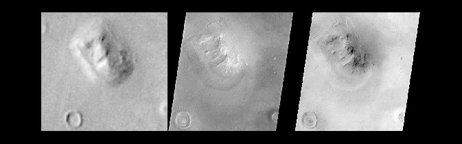
Original Caption Released with Image:
Shortly after midnight Sunday morning (5 April 1998 12:39 AM PST), the Mars Orbiter Camera (MOC) on the Mars Global Surveyor (MGS) spacecraft successfully acquired a high resolution image of the "Face on Mars" feature in the Cydonia region. The image was transmitted to Earth on Sunday, and retrieved from the mission computer data base Monday morning (6 April 1998). The image was processed at the Malin Space Science Systems (MSSS) facility 9:15 AM and the raw image immediately transferred to the Jet Propulsion Laboratory (JPL) for release to the Internet. The images shown here were subsequently processed at MSSS. The picture was acquired 375 seconds after the spacecraft's 220th close approach to Mars. At that time, the "Face", located at approximately 40.8° N, 9.6° W, was 275 miles (444 km) from the spacecraft. The "morning" sun was 25° above the horizon. The picture has a resolution of 14.1 feet (4.3 meters) per pixel, making it ten times higher resolution than the best previous image of the feature, which was taken by the Viking Mission in the mid-1970's. The full image covers an area 2.7 miles (4.4 km) wide and 25.7 miles (41.5 km) long. In this comparison, the best Viking image has been enlarged to 3.3 times its original resolution, and the MOC image has been decreased by a similar 3.3 times, creating images of roughly the same size. In addition, the MOC images have been geometrically transformed to a more overhead projection (different from the mercator map projection of PIA01440 & 1441) for ease of comparison with the Viking image. The left image is a portion of Viking Orbiter 1 frame 070A13, the middle image is a portion of MOC frame shown normally, and the right image is the same MOC frame but with the brightness inverted to simulate the approximate lighting conditions of the Viking image.
Processing
Image processing has been applied to the images in order to improve the visibility of features. This processing included the following steps:
The image was processed to remove the sensitivity differences between adjacent picture elements (calibrated).
This removes the vertical streaking
The contrast and brightness of the image was adjusted, and "filters" were applied to enhance detail at several scales
The image was then geometrically warped to meet the computed position information for a mercator-type map. This corrected for the left-right flip, and the non-vertical viewing angle (about 45° from vertical), but also introduced some vertical "elongation" of the image for the same reason Greenland looks larger than Africa on a mercator map of the Earth.
A section of the image, containing the "Face" and a couple of nearly impact craters and hills, was "cut" out of the full image and reproduced separately.
A section of the image, containing the "Face" and a couple of nearly impact craters and hills, was "cut" out of the full image and reproduced separately. Malin Space Science Systems and the California Institute of Technology built the MOC using spare hardware from the Mars Observer mission. MSSS operates the camera from its facilities in San Diego, CA. The Jet Propulsion Laboratory's Mars Surveyor Operations Project operates the Mars Global Surveyor spacecraft with its industrial partner, Lockheed Martin Astronautics, from facilities in Pasadena, CA and Denver, CO.
Mars
Galaxy
Mars